
Spatial Fragmentation in Nairobi City; the Elephant in the Room
Nairobi is recognised to be among the rapidly urbanising and growing economies in East and Central Africa. Eunice Jimmy reviews the city’s spatial, economic, and social structure, uncovering its dual nature of formal/informal, planned/unplanned, and connected/disconnected fragments, hence Nairobi’s spatial fragmentation.
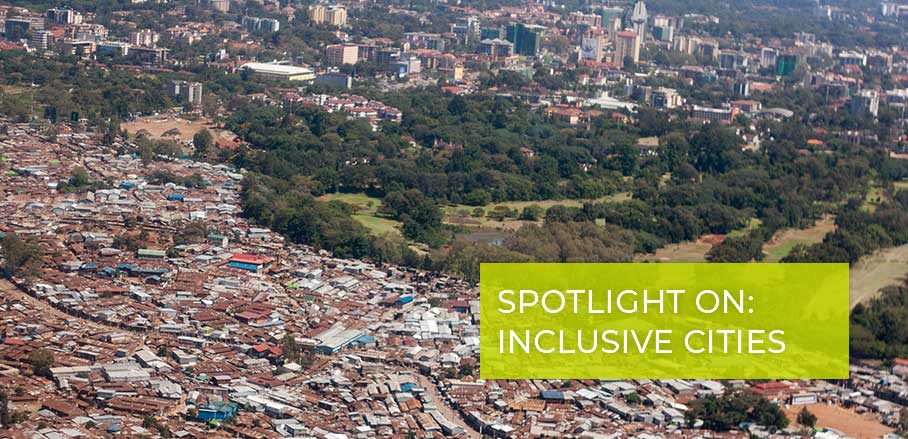
Spatial fragmentation is a widespread phenomenon and reality in Nairobi. Many middle and high-income residential neighbourhoods are located adjacent to slums and informal settlements, but are only separated by walls, fences, roads, or natural features like rivers.
For instance, Kibera, the largest slum in the city, is next to the Lang’ata upper-middle-class neighbourhoods. Mathare slum borders the Muthaiga affluent neighbourhood, just separated by Thika superhighway and Mukuru slum is located next to South B, separated by walls and a road. The fragmentation is fuelled by the principle of exclusivity whereby high-income and middle class residents isolate themselves from the rest of the city by living in enclaved gated communities. This kind of developments has resorted to a fragmented urban form in the city, social-spatial polarisation showing social and infrastructural differences from an aerial view of the cityscape (see the images). The city’s landscape is a typical representation of islands of wealth within an ocean of slums and informal settlements.
Drivers of Spatial Fragmentation in the City of Nairobi
The spatial fragmentation in the city of Nairobi can be perceived in two main ways. First, as a primary outcome of the colonial legacy inherited and, second, as urbanisation and globalisation having taken place in the city amidst improper regulations.
The historical growth and planning during the colonial administration have influenced the current social and spatial polarisation and urban form because zoning was based on race. The city was characterised by thoroughly planned areas for the whites in the west, and deprived ones in the east for the Kenyan natives, with restrictive regulations and policies. This is what initiated the growth of informal settlements and unauthorised housing developments. After independence (1963), the government’s capacity to plan and supply adequate public housing could not match the demand due to the high population growth rate and the migrants from rural areas, coming to the city searching for opportunities.
Hence, the private sector became the primary provider for development and utility service, targeting the city’s middle-income and rich population to maximise profit margins. This, coupled with the lack of a social welfare system to provide housing to lower-income citizens and the poor, has resulted in intergenerational marginalisation, with the poor settled in the slums and the lower middle class opting for various forms of informal and illegal residential development practices to access housing such as construction without following official planning procedures. This resulted in fragmentation of the city, in well-planned neighbourhoods for one part of the population and unplanned residential neighbourhoods and uncontrolled developments for the other.
The improper regulations and failure of city planning in terms of preparedness for the city’s growth and failure to designate adequate land for planned urban growth led to the haphazard development of informal housing by the middle-income group at the city fringes, contributing to fragmentation. Gated communities, which are the trending and thriving types of developments in the city due to high demand and supply by the elite developers, tend to encourage a ‘closed city’ or ‘fortified enclaves’, a major manifestation of fragmentation.
The neighbourhoods differ in several characteristics such as housing typology and urban form, access to public goods, and infrastructure and services provision. These differences, associated with the respective inhabiting social group, manifest the high spatial disparities and inequalities. The affluent live-in areas that are well-planned (and mostly gated) have privatised spaces, good infrastructure, and utility services. On the other hand, the poor and lower-income groups live in dilapidated, congested, high-density neighbourhoods with inadequate or insufficient public services. This is a situation Jane Jacobs calls ‘islands within the city’, and I refer to it as ‘cities within the main city’ or ‘well-off fragments within a disconnected city’.
Spatial Fragmentation and Exclusion
Fragmentation accentuates disconnections because they are strongly related to barriers that hinder choices and opportunities for social and spatial connections and interactions. For instance, some barriers created by gated communities block public roads and disconnect people from each other, making it hard for close neighbours to have physical interactions due to the spatial relations between the estates. The physical barriers such as walls, fences, and barricades that separate the neighbourhoods from the rest of the city reinforce residential segregation and fragmentation, undermining integration of residences in the neighbourhood.
Also, gating within neighbourhoods discourages street life and encourage insecurity perceptions. The barriers also promote urban inequalities through limiting social development that fosters a sense of belonging within neighbourhoods, thus making it harder for the poor to become part of the city. For instance, when informal settlements are physically isolated and disconnected from urban fabric through walling and public roads closures, they are denied the right to integration and access to the city because they have longer commutes and higher cost of transportation.
The urbanites in the isolated areas face both social and physical distance between the well-off and the poor neighbourhoods. This exhibits a spatial poverty trap, articulating itself in noticeable issues such as worsening living conditions, social exclusion and marginalisation, lack of social interaction, high incidences of crime, gender disparities, and severe job restrictions, as outlined in the UN’s 2010 State of the World’s Cities Report.
Spatial Planning and Inclusive Cities
While spatial planning can create inclusive cities, sometimes the same planning tools have been employed as instruments for exclusion, especially when partitioning of the urban areas is based on socio-economic statuses and when the regulatory tools promote gated communities without providing for the poor. Nevertheless, spatial planning can still be used to attain an inclusive city, especially in delivering concerted solutions to address the fragmentation by combining people-based policies (focusing on the isolated group; the poor and the lower-income groups) and area-based policies (focusing on the unplanned and informal zones; the excluded areas). The will of the involved stakeholders (political, planning, and developers) to address this issue is the most crucial aspect towards realising inclusivity; otherwise, exclusion, marginalisation, and discrimination of the poor will continue to thrive.

- Spatial Fragmentation in Nairobi City; the Elephant in the Room - 29. April 2021