
Mapping Makoko: A Community Stating its Right to Exist
Makoko, one of Lagos’ largest slums, used to be a blank spot on the map for most of its history. This has been changing with a community-based digital mapping project that enables the residents to articulate their rights.
Makoko – A Short History
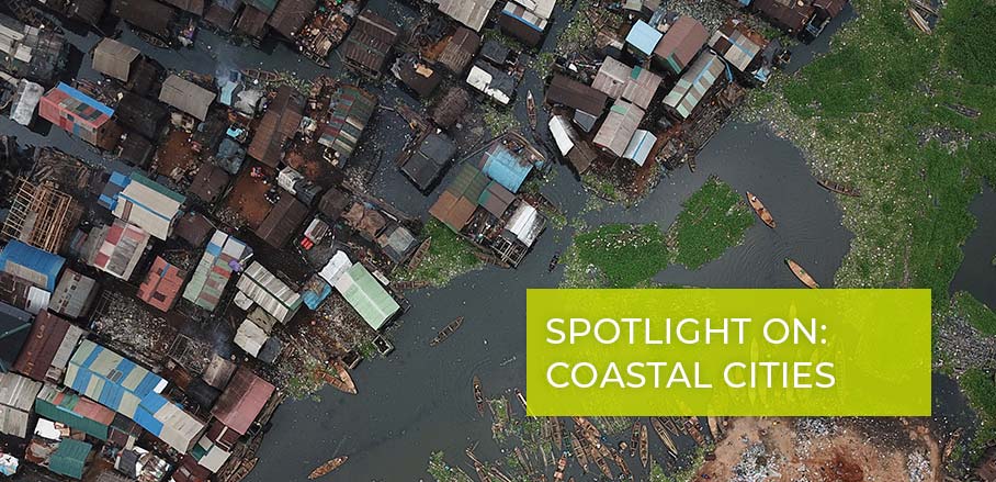
Makoko, a water-front settlement in the centre of Lagos, Nigeria, is estimated to be home to around 250,000 people, most of whom live in difficult conditions. Despite being only a few kilometres away from the financial centre of the city, not far from the oil and gas companies’ headquarters in Victoria Island, the place used to be a blank spot on the map until recently.
This changed when a team at Code for Africa, a non-profit organisation working on civic technology and digital transformation in African countries, worked with the local community to create a bottom-up, open source map of the area using drones, smartphones, and crowdsourcing. Putting themselves on the map was a way for the community to state their right to exist.
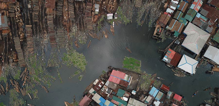
Drone Shot of Makoko © CodeForAfrica
Makoko is one of Africa’s most unique inner-city slums, with a third of the community built on stilts in a lagoon off the Lagos mainland – the famous Nigerian megacity populated by about 21 million people. Transport in Makoko is by canoe. The rest of the settlement is on swampy land with little sanitation and few public services. Makoko started off as a fishing settlement, with family groups migrating there from the Benin Republic in the 19th century. An old map from 1962 shows the Makoko Community in an almost empty Lagos – when the population counted less than 1 million people. The most prominent language spoken by the local community in Makoko is called Egun and it is a blend of French and other local Nigerian languages.
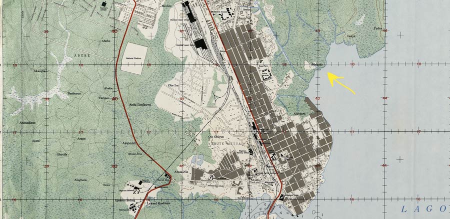
Old map of Makoko from 1962, © Wikicommons | PD-USGov
Since 1962 the population of Makoko (as that of Nigeria) has grown dramatically, but the statistics about the settlement and its communities are hazy, as the area appears as a near-blank space on maps – with little information about structures, density, or streets. This means it is almost impossible to properly track land ownership, plan infrastructure, optimise services, plan for emergencies, or support development. In short, not being on the map means that authorities never adequately allocate resources to Makoko.
Meeting the Threat of Displacement by Mapping
The people of Makoko have been under huge pressure in the last few years due to the rising value of land. Gentrification and real estate projects are threatening their right to live in the area they have been living in for the last six decades. Such pressure turned into actual displacement in 2017, with thousands having to leave their settlement; a government-ordered eviction that was deemed unconstitutional by the Lagos High Court the same year.
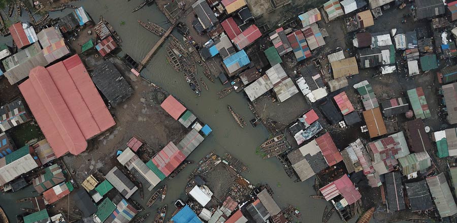
Code for Africa, a civic tech and data journalism initiative working in the continent, decided to partner up with the local community to create the first bottom-up, crowdsourced map of Makoko. The objective of the project, supported by the Humanitarian OpenStreetMap (HOTOSM) and the Pulitzer Center on Crisis Reporting, was threefold: training local young people to fly drones and collect geo data by using GPS and Open Data Kit, create a detailed map of Makoko now available to the public on OpenStreetMap, and run a map-driven, data journalism campaign on the living conditions in the area.
Drone Shot of Makoko © CodeForAfrica
The training took place in Lagos in November 2019, in cooperation with the local NGO Makoko Dream, African drone initiatives Uhurulabs and AfricanDrone, with support of the American Corner in Yaba, Lagos. The sessions trained 32 persons on becoming drone pilots and mapping the area using the technology. The drone missions captured high definition images of Makoko, which were then stitched together into shapefiles and then labelled by the local community using Open Data Kit and processed by the HOTOSM community. Now, there is a detailed map of Makoko available on OpenSteetMap – an impressive development if one compares the before and after pictures.
Challenging Traditional Models
The idea of creating an inclusive map aims to challenge the dynamics of the more traditional, top-down development work. As Code for Africa’s project manager and mapping expert John Eromosele said during an interview, “We would not be able to achieve this if we did not carry the community along. Makoko is usually very careful with projects they approve or endorse in the community. People just come and take pictures of them, then disappear into thin air after the project. But as we all know, mapping is a continuous process”.
One of the intuitions behind the map was response to emergencies. The map could be useful in the case of climate crisis: with rising sea levels, people will be facing huge problems. But also in a case like the Covid-19 pandemic, the map can be used as a tool by international organisations and also by the local government to organise support and distribute resources to the community. Code for Africa also reached out to the Nigerian Red Cross, which works not far from Makoko, to explore how they could deploy the map to organise their work.
The story of MapMakoko caught the attention of many media outlets, both Nigerian such as The Guardian Nigeria, and international like Al Jazeera, Africa French Press, CNN Africa and Devex, among others).
Why Mapping is Political Action
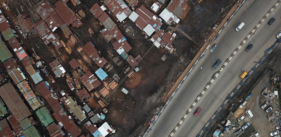
Schools, pharmacies, markets, restaurants, water sources, churches, mosques, and shops: the people of Makoko could decide what to put on their map. All maps are very practical, but also political. Bottom-up, demand-driven, open source maps like the one of Makoko have an added value, because they are the fruit of a participatory process. An open source map will serve the community as a means to state their existence as well as to coordinate a joint effort to improve their living conditions.
Drone Shot of Makoko © CodeForAfrica

- Mapping Makoko: A Community Stating its Right to Exist - 24. September 2020