
Climate Information for Sustainable and Resilient Urban Planning
The impact of climate change is especially concentrated in urban areas and is projected to increase in the future. Using climate information in urban planning, however, can build resilient cities and enable sustainable development. By Saskia Buchholz from the German Meteorological Service.
The new global and regional temperature records during the last decade have increased the acceptance that even municipalities that had been so far little or not affected by heat have to take precautions against it. Thus, urban planners, practitioners and decision-makers require knowledge on the climate of their city and its development in the future. Furthermore, they need information on the effectiveness of climate adaptation measures to achieve climate targets in their respective urban settlement, as not all measures work equally well everywhere.
Different Cities, Different Climates
Indeed, changes in climate are observed in all geographical regions around the world. However, many emerging climate change risks are concentrated in urban areas, due to the high building and population density, as well as the concentration of infrastructures and supply systems. After all, every single modification of the natural land cover and its properties leads to local climate changes. In the city, for example, temperatures are typically higher, ventilation is weaker and air quality is poorer compared to the surrounding countryside. This difference in air temperature between the city and its cooler countryside is referred to as the urban heat island (UHI) effect.
Buildings and sealed surfaces in the city store a large amount of the radiated solar energy during the day – and during the night, the energy is slowly released as heat, thus preventing the urban atmosphere from cooling down more quickly. Furthermore, various local climates can develop within the city itself depending on the building density, radiation and thermal properties of the building fabric, the surface sealing or the proportion of vegetation.
Rising temperatures, heat stress, water security and quality, sea-level rise, storm surges, extreme weather events, inland flooding – yes, the impact of climate change on cities can be manifold. Climate change adaptation, especially with regards to tackling the devastating effects of globally rising temperatures, should therefore be at the very heart of urban spatial planning.
Using Climate Information to Counteract Heat
Heat is considered a deadly weather-related phenomenon over much of the inhabited world. Excessive heat events have a devastating impact on human health by increasing heat-related morbidity and mortality among the elderly, people with pre-existing illnesses, small children, and the poor. Under a future warmer climate, prolonged and intense heat waves are more likely to occur. Within cities, heat events are further intensified by the UHI effect. The extent and distribution of heat load problems within the city is often identified through the use of urban climate models or urban climate measurement networks.
Wind, however, ensures the exchange of air between the city and the surrounding countryside and may reduce the differences in air temperature and air quality. High wind speeds generally favour low UHI intensities and lower air pollution concentration in cities. The conservation or enhancement of urban ventilation in a warming climate should thus be secured by spatial planning.
The ventilation of cities can be provided either through large-scale weather conditions or by local wind systems. The latter are stimulated by local-scale air temperature differences due to topographical terrain or land cover conditions and play a major role in the ventilation of a city under calm synoptic weather conditions. Cold air drainage models and urban climate models can provide the necessary wind, as well as air temperature and heat flux data in order to identify the important cold and fresh air source areas and the paths that connect these areas with overheated settlements.
Climate Adaptation Measures Against Heat
Adaptation measures that counteract the heat load in the city include not only the protection of areas and transport paths of cold and fresh air but also maintaining, expanding and creating more water and green areas; for example, by installing green roofs and facades. In addition, unsealing or the use of higher reflective materials also contribute to heat reduction.
Also, the “sponge city” concept is an ideal solution to counteract the negative impacts due to heavy rain events, heat waves and dry spells. The concept is based on a combination of measures that absorb and store the rainwater during heavy rain events – for instance through permeable materials or water retention basins – to prevent local flash floods. The reuse of the stored rainwater for irrigation can reduce the urban heat island effect and help to better overcome long-lasting droughts in the city.
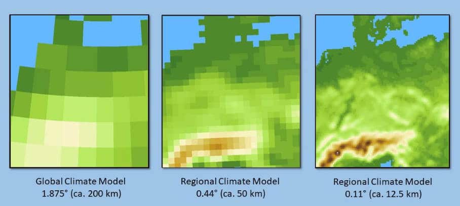
The resolution of global and regional climate models is not enough to map the urban climate © Deutscher Wetterdienst
Making Use of Climate Models
Spatial planning should also consider the evolution of the urban climate under a changing climate – and climate models play a key role in this regard. A climate model combines a large number of sub-models into one large model. The sub-models describe all essential processes of the atmosphere, hydrosphere, cryosphere and biosphere of our earth. For the modelling purposes, the earth’s atmosphere and ocean are covered with a three-dimensional grid. The spatial resolution of the atmospheric grid is around 200 kilometres for global climate models and 12 – 50 kilometres for regional climate models (RCM).
This limits the computing time needed to calculate the climate over many decades to centuries. RCM results can be utilised to gain general information on the changes in climate expected within a greater region. Typically, they do not capture features like the UHI or thermodynamically driven local-scale flows that are important for urban ventilation.
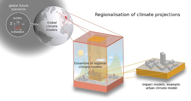
Downscaling models: From global emission scenarios to the impact of climate change on cities © Deutscher Wetterdienst)
Therefore, to obtain climate information on city-scale, the results of the RCMs are downscaled. This can be done by high-resolution RCMs coupled to urban land surface schemes (dynamical downscaling), empirical statistical downscaling, or a combination of both. The cuboid method developed by the German Meteorological Service is a statistical dynamic downscaling method for calculating heat-related climate indices, which provide the present and future heat load information needed for urban spatial planning purposes.
Taking climate information into account in urban planning not only helps to arm our cities against the impacts of climate change. Rather, the measures implemented as part of climate adaptation also serve to significantly increase our quality of life and maintain the health for urban populations everywhere.

- Climate Information for Sustainable and Resilient Urban Planning - 20. January 2021