
How Digital Data and Mapping Shaped Bangladesh’s Urban Climate Resilience Plans
Female indigenous residents of informal settlements in coastal Bangladesh are especially vulnerable to risks induced by climate change. Digital mapping ensures that they are adequately considered in the development of urban climate resilience plans.
What Makes Female Indigenous Residents Vulnerable?
The particular needs of female residents like safe spaces, separate bathrooms (with a toilet), exit ways, water points, and courtyard lights are rarely articulated, identified, or recognised in development in general. This tendency is continued in climate resilience planning for these communities, which is not aware of women-specific vulnerabilities in climate risks – and is exacerbated by a general lack of awareness for the impacts and risk of climate change in these communities.
Most importantly, women and indigenous households are not in on the dialogue with authorities on data, information, and mapping for informal settlements, nor are they part of municipality development plans and projects. Municipal authorities lack climate resilience plans as well as tools and methods such as geographic information systems (GIS), open data kit (ODK) mapping, and social mobilisation, which would engage these vulnerable communities in designing and developing integrated urban climate resilience plans in Bangladesh.
What Could A Community-Based Approach to Urban Climate Resilience Plans in Bangladesh Look Like?
Responding to these shortcomings, port municipalities Kuakata and Mongla in the Bay of Bengal Belt implemented tools and methods to form a gendered urban climate resilience plan. Badabon Sangho is a women’s rights and women-led organisation that aims at facilitating the process by engaging with women, youths, and authorities. For this, GIS-ODK tools were utilised in different level of data collection, validation, and planning. Badabon Sangho has been partnering with Cadasta Foundation and using its platform for a long time.
In 2019, a total of 50 youth (32 girls and 18 boys) volunteers were selected to aid with the data collection after receiving a three-day training. A questionary to analyse female residents’ particular needs was developed and uploaded on the GIS-ODK application. Each volunteer visited households and collected responses. In addition to the household information (name, household members, income, years of living,), they also collected data on the geo-location of the house within the settlement. Our volunteers experienced that most of the homes are congested and attached with each other, it is difficult to demarcate their boundaries.
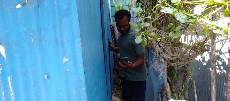
Data collection © Badabon Sangho
Prior, during, and post data collection, a series of social mobilisation methods were implemented, aiming at engaging community members. These included the formation of women groups, youth groups, and indigenous peoples groups, as well as the coordination of monthly group meetings, joint group meetings with local municipal authorities, courtyard sessions and meeting with journalists. A community-based Climate Change Resilience Plan Development Committee was formed, consisting of civil society members, journalists, women group leaders, businessmen, et cetera. The committee organised a series of meetings, consultations, and learning sessions to orient residents and elected bodies on the importance of climate resilience plans.
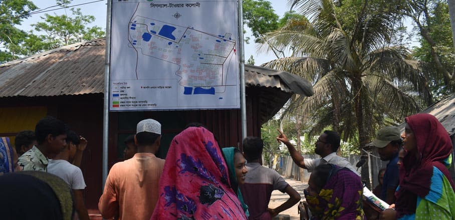
Finally, a total of 1,149 households’ data was collected, validated, and recognised in the urban plan. After the validation, this data was analysed and presented at a municipal budget review meeting. Informed by the discussion, a climate resilience plan has been developed. Visualisations of the plan have been printed out on maps and are shown on billboards.
The aforementioned needs and priorities of women were indicated on the printed map. Each informal settlement developed one map and presented it in front of the community. Youth groups, committee members, and women groups are functional and continuing advocacy for budget allocation and project implementation. In the future, the databases may also be used to help resolve land tenure issues for indigenous and women-headed families.
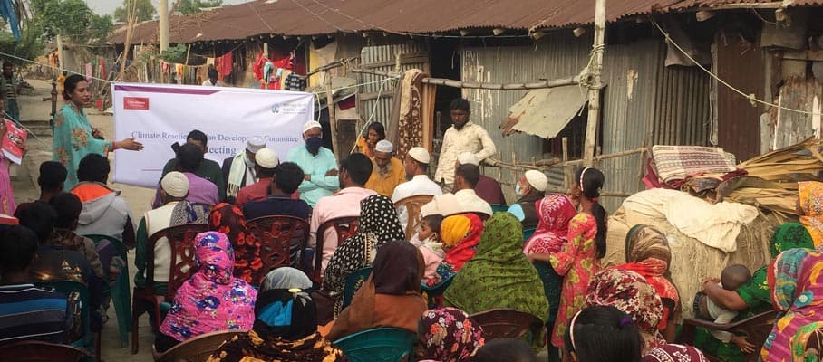
Community engagement © Badabon Sangho
What Learnings for Future Projects?
- Most of the women-headed households and Rakhine families lack ownership documentation, making geo-location data harder to collect. It was hard to use the map for women’s land tenure security.
- In the Kuakata municipality, government employees shared the planned schemes for city development, such as for embankment and drainage system with ministry officials only, while other elected councillors were not informed and thus not aware of those schemes. Furthermore, the planned schemes are not consulted with the residents; residents tend to be only informed when a project is already being implemented. There is clearly a lack of communication between government employees, elected bodies, and residents, caused by a lack of project development and approval processes and practise thereof.
- Municipalities do not have the financial capacity to implement planned schemes, making them dependent on national politics and budget.
- Connecting roads within slums are informal and not mapped by municipality – doing so would be helpful for walkway and sanitation planning.
- Vulnerable women and indigenous people are capable to communicate their needs in front of political leaders.
- With an upcoming municipality election, potential candidates and existing elected bodies are busy maintaining relationships with political parties and have less time for development planning and implementation.
- Consultation, budget reviews, and map presentation meetings with officials have proven to be very productive. They helped especially newly elected to understand the priorities of urban vulnerable communities.
- Maps on billboards are key tools for public awareness of resilience plans. Youth volunteers can facilitate the awareness process.
The Climate Change Resilience Plan Committee will continue to work with authorities on a long-term basis as a local non-state actor. Badabon Sangho will maintain its local presence and will continue to work on the resilience plan implementation as well as its engagement with residents, civil societies actors, vulnerable communities, youths, government officials and cities’ elected bodies. Courtyard sessions and consultation with vulnerable communities will be continued beyond the project phase, ensuring their long-lasting involvement into the decision processes influencing their everyday lives.
