
Hang in There, Chennai!
Chennai’s wetlands are prone to disastrous floods and droughts. Jayshree Vencatesan delves into the city’s past and shows just how important understanding city hydrology is for urban planning.
Chennai, formerly known as Madras, is the 36th largest city in the world with a population of 11.2 million. From a small cluster of fishing and agrarian villages in the 1800s, the city now spans over 1189 square kilometres with plans for expanding into an 8800 square kilometre metropolis, which would make it the largest city in India.
The historical city is located on the Indian East Coast and abuts a warm sea, the Bay of Bengal. Its coastal orientation defines all its facets, while at the same time rendering it vulnerable to consequences of climate change. Although wetland neglect and misuse have been considered by many researchers as the primary cause of flooding, it was the 2015 floods, which earned the ubiquitous nickname “Mega Floods”, that finally brought the much-needed attention to Chennai’s wetlands. These floods exposed the deeper and more serious issue of wetland mismanagement as a causal factor. The absence of integrating wetland management into the growth and development plans of Chennai became starkly apparent, which was further reinforced by the drought of 2018/19.
Indeed, the coast of Chennai is best described as a double-edged sword, serving both as a buffer to climate change impacts while at the same time being a fragile habitat – and if we are to increase its resilience, it is imperative to understand the formation and history of Chennai’s wetlands first.
Classifying Chennai’s Wetlands
Historiography suggests that Chennai was typified by vast tracts of wilderness with intermittent agrarian patches that were irrigated by man-made wetlands. The coastal wetlands of Chennai are described as near natural and can be categorised into estuaries, backwaters, oxbows and saltwater marshes, with vegetation ranging from sparse mangroves and littoral forests to grasses and sedges. The hinterland is typified by man-made wetlands that can be categorised as lakes, tanks, pools, and temple tanks. The ancient Tamil classification of the wetlands accommodates seasonal wetlands, stagnant puddles, channels, conduits, storage systems and so on. This system of the wetlands has popularly been referred to as the “Eri-System” – an Eri being a traditional man-made reservoir to conserve water. Eri-Systems were built to store rainwater, prevent flooding and refill groundwater.
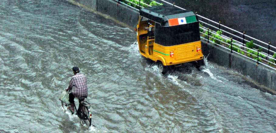
A flooded street in Chennai © Pandiyan V/flickr (CC BY-NC 4.0)
Furthermore, the manner of the on-ground organisation of Chennai’s wetlands is rather interesting and demonstrates the deep understanding of traditional communities of the landscape’s hydrology. Broadly, while the wetlands of the hinterland are organised as satellite complexes, those closer to the coast follow the cascade system. Both systems facilitate channelised and sheet flow of water, primarily to water rice fields and enable inland fishing.
In the past, from at least the 18th century onwards, summers kept the wetland bed moist but not filled to accommodate the cultivation of summer crops. Until the 1970s the regulation of flow, maintenance, and repair were fostered mutually through official channels, with a designated member of the city department in charge of the upkeep of wetlands, called the “Lashkar”, as well as through the community deciding on the mode of discharging water.
Chennai’s Colonial Hydrological History
It was especially the presence of the British that would significantly and negatively impact the city’s hydrology. Two examples stand out in this regard: firstly, the creation of the Buckingham Canal, which is a shallow, navigation canal running North to South, parallel to the coast. It was carved out by linking coastal wetlands of the landscape and was regulated by strategically located weirs and gates. Also, it became the endpoint to the seasonal rivers that drained West to East.
The Buckingham Canal impacted the hydrological regime of Chennai by converting some coastal terrestrial systems into brackish water aquatic systems. The terrestrial habitats were common lands of the fishing communities. Further, since it was a shallow canal, flows were determined by seasons and the hot and humid weather of Chennai rendered portions of the canal dry, thereby furthering seawater intrusion. The flip side of the canal was its effectiveness in mitigating flooding and waterlogging.
Secondly, Chennai historians believe that the tussle for territorial control between the British and the French led to the emergence of centralised distribution of potable water. This in turn necessitated the creation of reservoirs, which was achieved by deepening the large seasonal wetland called the Chembarambakkam Lake, which remains the primary source of fresh water for the city. The centralised system created hierarchies of distribution. The system was designed to capture the maximum quantum of water from adjacent wetlands into the reservoir, thereby further impacting farming and fishing communities.
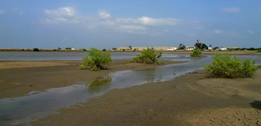
Coastal mudflat in Chennai © CET
Later on, independent India created a system of managing wetlands through a standout policy, the Eri Scheme of the 1970s, a populist housing scheme by the Government of Tamil Nadu. This scheme facilitated the active conversion of wetlands into housing, residential and public infrastructure zones. Consequently, many significant wetlands were either destroyed or fragmented beyond redemption. This transformation was facilitated by the state’s adherence to an archaic land classification system whereby large tracts of shallow, seasonal wetlands were classified as wastelands.
As the city now faces recurrent floods, it becomes apparent that historical planning fallacies, especially concerning wetland mismanagement, are derailing Chennai’s future development rather significantly.
The Future of Urban Planning in Chennai
The much-needed focus on integrating wetlands and vegetation into Chennai’s urban planning is in its nascent phase at best. While moving towards a comprehensive strategy is a cherished hope, still, impediments persist; one being the debate over the number of wetlands. Estimates in Chennai range from a meagre two digits to thousands. That the existence of 474 wetland complexes would be a more robust target is yet to find acceptance. This lacuna also contributes to singular wetlands being the focus as opposed to systems.
While the government department vested with the task of wetland maintenance continues to manage the wetlands as part of the irrigation system, local communities, often recent immigrants to the city, demand that they be converted into micro reservoirs which also have a public space component. This represents two ends of a spectrum.
With a view to the future, Chennai needs to evolve a strategy that embraces a systems-based approach, in which the 474 wetlands are characterised adequately, and specific plans are evolved. This may call for certain wetlands being protected as inviolate entities, while others may be modified to serve multiple functions. It is unfortunate, yet true, that much of the current restoration in Chennai is limited to dredging and desilting close to the embankments, thereby destabilising the wetlands’ integrity.
Fanciful interventions, such as creating hillocks in the lake beds or amphitheatres around the foreshore bund, are some of the extremely popular interventions. If Chennai’s resilience needs to be buffered by wetlands, we need to delve into its history while evolving science-backed strategies and activities that can address future risks.

- Hang in There, Chennai! - 17. June 2021